Saturday, August 22, 2009

On our own in the wild

On Monday we bade farewell to the folks and started heading West on our own. Our first stop was Pictured Rocks National Lakeshore in Michigan. I haven't been there since I was 10 and even then it was only from the shore. We made a few wrong turns then flew down the highway going way too fast to make the 1pm boat cruise. It was worth it. A beautiful sunny day made for some nice shots. If we had more time we would probably rent kayaks and spend a day paddling the shoreline. If you were up for a long hike/unsupported run the 40 mile trail along the coast would be nice too.


After a few hours on the boat we hit the road for Voyageurs National Park in Minnesota. We didn't make it in 1 shot but leaving Pictured Rocks at 4 gave us 3-4 hours down the road.


When we arrived at Voyageurs NP on Tuesday we were a litte dissapointed. We knew going into it that Voyageurs is one of the least visited NP's out there and that it was a huge water park and a boat would be helpful in getting around. What we didn't expect was the scarcity of resources available locally. We walked into the NP visitors center and found 2 "rangers" on their first day alone. The reading material we already had was more useful. When asked how far one can reasonably expect to paddle in an hour one asked the other "how fast do you row? 4? 6 miles per hour?" To which the older gentleman said "I dunno I only row downstream. "

We drove down the road to Ash River State Park to rent kayaks for the trip. The entire town had 2 small kayaks that certainly weren't going to handle packs for a backcountry trip. Even fewer people here had any idea how long it would take to paddle a canoe out to a site. So we got a trail run in and crashed at a small state campground.


Thursday we went out in a canoe for a few hours and found the park to be very nice. It only took us 1.5 hours to paddle from Ash River to Kabetogama lake and another hour would have easily landed us a camp site. But with thunderstorms forecasted and not knowing how long it would take us, we turned around and hit the road around noon.

On our way to our planned stopping point in Fargo, ND Meg discovered this gem of a country store.


Here we discovered we were only a short distance to the headwaters of the Mississippi, so we pulled over and took a shot.


We stopped for the night in Fargo, ND. We were quite dissappointed to find out that Fargo is quite a busy town and not the quiet little backwoods town as portrayed in the movies. It's so big that it would have required some research to figure out where the statue they raised for the DVD release of the movie was located.

Wednesday, August 19, 2009

Moving Westward

On tuesday after a great time with friends we pulled out of Maine and drove about 8 hours to Rochester to have dinner with Meg's mom and crashed at Sarah and Colin's house. We had a nice time but left early in the morning to have breakfast with Meg's grandparents. We got a track workout at Meg's old high school (it has been significanty ugraded since Adam ran track on it). Finally after a quick shower we pulled out of Rochester to head towards Michigan.

We made it through Canada without incident. (Good, because we didn't exactly tell the rental company that the car was going to leave the country.) My folks left for Paradise on Wednesday so we pulled off in beautiful *cough* Flint, MI for dinner and some sleep. We hit the road fairly early and made it to Tahquamenon Falls State Park in the mid afternoon of Thursday.


We checked out the second tallest falls east of the Mississippi and had a good time catching up with the fam. On Saturday, Meg & I got up early for a race. I did the 25k while Meg's knee held her back to the 10k. The first 10 miles were pretty and over rolling hills but the last 10k had tons of stairs and it was very obvious that I went out way too fast. Still, it was a nice day on a nice course.

On Sunday we checked out the shipwreck museum and had a good time reading about the hundreds of wrecks on Lake Superior.


-- Post From My iPhone

Tuesday, August 11, 2009

Maine Mosquito Madness

After a slight delay in NYC, we eventually pulled into Cape Elizabeth, Maine at 11:30 pm. It was hard to tell then, but we woke up the next morning across the street from the "beach." The beaches in this part of Maine appear to be some form of shale and the rock forms slabs that go all the way to the water. It's beautiful, but not exactly friendly to sand castles.


Saturday was spent walking around the shoreline and the state parks. Eric and I lost our respective wives and spent over an hour looking for them only to discover they had gone home earlier. I got a 40 minute bike ride in while hunting for a farmers market that apparently closed 3 years ago. After returning with some veggies, Meg & I got a 40 minute jog in. (Her knee is still bothering her from an overuse problem, it appears. )


Sunday we went to downtown Portland where we caught up with my friend Derek who I did Ironman Lake Placid with. He now has a 1 year old and lives in Kansas City so it was nice to spend some time with him and Kelley catching up. We will try to stop by his neck of the woods on the return trip.

Monday, I got a very humbling 10 mile run in. For the first time on that much asphalt in nearly 2 years it went ok, but I'm a long way from my old form.

We had been saving our stereotypical Maine lobster meal for Monday night. With 11 people and only 1 pot we would have to eat in shifts -- no problem we said. Since lobsters are pretty messy and the ring burner had to be outdoors we decided to eat outside on a nice evening. Batch one of the lobsters were done at 7:45. As soon as we started eating the crustaceans the mosquitoes started swarming and eating us. I've seen dome nasty mosquitoes in Michigan while camping but this was the worst I've ever seen. Round one scarfed their lobsters down as fast as possible. While round two were boiling we moved the table away from the burner -- mosquitoes are allegedly attracted to propane. That provided some limited relief but those eating in round two had to inhale their lobsters or risk bring carried away from the table. It was kind of comical, but also dissappointing that we couldn't savor the lobster a bit more.


Tuesday morning arrived far too quickly and we said good bye to our good friends and hosts Jen and Eric along with everyone else. We'll hopefully see many of them again in September at the Big Schloss.


-- Posted From My iPhone on I-90 in upstate New York headed towards Rochester.

Friday, August 7, 2009

The Road Trip Begins

We managed to hit the road today by 11 to start our road trip to Maine. We got through Phily without too much trouble, but hitting the George Washington Bridge in NYC @ 5pm may not have been the best idea. Either way, the adventure has begun and we're moving.


-- Posted From My iPhone while moving 0.5 mph in line for the GW bridge.

Friday, July 31, 2009


So today is my last day. It had to come. The internet has to go. So the next time you see me online, I'm hopefully in your timezone. (Unless you're following me from anywhere other than Eastern standard time, in which case, I'm still not in your timezone, but maybe a little closer.)

See you soon maybe?

Thursday, July 23, 2009

Where does a Brit in Tbilisi go from here to get to India?


The Telegraph is running a diary about a cyclist on a 6,000 mile ride. He's currently in Georgia which is how I found out about him with my Google News update.

This guy is riding from the UK to India and was originally planning on doing so through Iran. With the recent change in the political situation, he's decided that may not be the best idea. So, he's in Georgia now.

Presumably that implies his original plan was to go Turkey/Iran through the narrow border they have.

But where is he going now?


View The Bicycle Diaries in a larger map


If you avoid Iran by traveling through Georgia/Azerbaijan... from there you either:

Take the boat across the caspian into Turkmenistan or Kazakhstan

or Ride your bike from Azerbaijan north into Russian to go around the Caspian into Kazakhstan. (Sounds like an easy ride, what do you think?)

But my real question is: where do you go from there to get to India?

If he stuck with Iran, you could arguably hit the Indian Ocean shores and avoid Baluchistan and hope you make it through southern Pakistan before getting into India.

But now that he's avoiding Iran and almost certainly going through the north, he's either riding THROUGH AF/PK. (Yeah, that's a good idea) or approaching India from the Himalayans. (Either through China or Kashmir)

This might be worth following just to see how he gets out of this one.

Wednesday, July 15, 2009

Life at 16,512 ft is apparently very white

IMG_1204

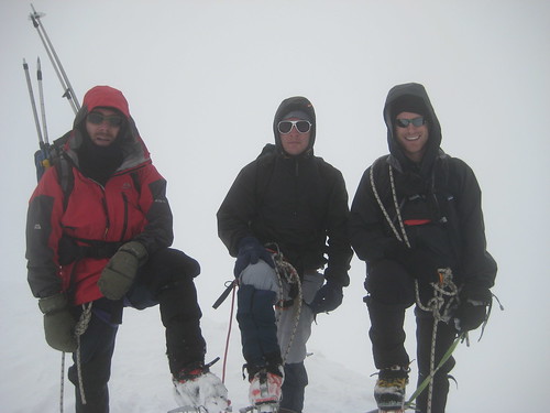
Who would have thought that you could save yourself a lot of time, effort, pain and money by just borrowing some mountaineering gear and taking a photo in front of a white sheet? Such is what my experience of life at 16,500+ feet was like. I'm not sure if it was the hardest thing I've ever done -- Ironman Lake Placid holds a special place in my heart for that -- but it's DEFINITELY the hardest thing I've never trained for. Also, while Ironman was a long 10 hours and 40 minutes, this was a long, very hard 4 days.

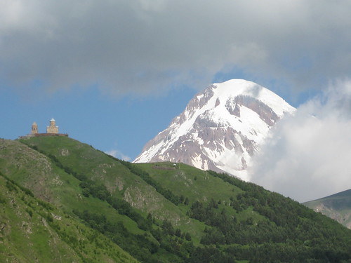
Sunday started with a 6:30 am meeting to get in the cars and head up. We pulled into Stepansminda (formerly known as the town of Kazbegi) by 11, got a cup of tea then drove up to the Holy Trinity Church to start our climb. (Some folks start at the bottom and hike up to the church, but that's an extra 1-1.5 hours of wear & tear we didn't feel necessary.)
IMG_1217

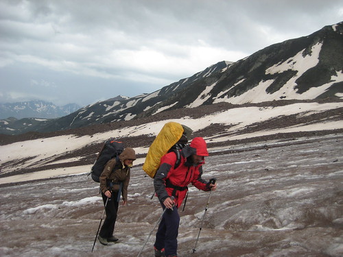
So, we kick off at about 11:40 at 2400m. We hike up through some alpine meadows and have an interesting time crossing a run off stream into a camping area used by many along the ways. (3145m, About 4 hours to get here.) That was already a pretty solid hike, but no kids, we're not done yet. We start heading up the moraine of a glacier, walk up onto an icy slope and once we're up on the glacier, start trekking across it. The hike across the glacier was work, but not that bad despite the light drizzle we had for an hour or so. But after 7 hours of hauling a 45 lb pack up 1300m (4200 ft!), the last 100m up a ridgeline to the old meterological station was pure misery. It has been a long time since I've had to set goals 10 ft ahead of me. Ow that hurt.
"Church" at 4200m

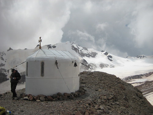
Monday morning arrived and we all woke up with the worse hangovers we've ever had. Air at 3800m (12,400 ft) is in short supply and it makes for some unpleasant sleeping. But, you shove some food and fluids into you and eventually you feel better and we went for a hike up to a small chapel at 4100m. Apparently one of our guides had a friend who was married in this chapel. After having our fun on the steep snow where we didn't really cover much on the safety side of things, we returned to the meterological station to rest up and get ready for an early morning wake up.


At 2:30am Tuesday morning (technically) we wake up to grab some food before our long day. At this point I should point out to you that the short walk to the toilet still winds me. I tried to shove 2 packets of oatmeal into me, but 1.5 was about as much as I could muster. Armed with some clif bars and 3 bottles of Powerbar Endurance (my favorite version of Gatorade) we headed out. After an hour of hard hiking in the dark over snow and rock fields, we took a break. I did some math and realized that assuming we weren't going to refill bottles, I had a budget of about 1/4 of a liter per hour for our trip. Don't worry I wouldn't have time to actually drink that much.

We moved and we moved fast. As the sun came up we found ourselves along a rock wall with a bunch of watermelon sized rocks on the ground. We skirted them as much as we could, but as we walked by I knew we should have had helmets on. We continued pass a crevasse field and up to a high plateau in a snow field at about 4200m. Some teams apparently only go this far and set up a high camp here. But we continue on up the snow fields.

At about 4500m, Ron decided that he wasn't keeping the pace and that he would be better off on a second rope team. I disagreed with him at the time, but in hindsight seeing what I went through, it was the right call. So we pushed on. Now it's 3 guys who smoke a pack a day apiece dragging me up this hill. (How is that even POSSIBLE?) Somehow I'm the guy who's dragging in the rear, but we catch up to this other rope team of about 10. They're moving a lot slower than us (they left 90 minutes earlier than us) and the weather has started to deteriorate. Visibility was about 50 ft or so and their rope team appeared to be floundering around -- either due to the guide not knowing where to go, or the team not moving very well.

We eventually pass them and Levan found the line to the top without too much apparent difficulty. (There is no way even with the best maps I could have found this. Good job, Levan.) The last 100m of elevation to go though are steep snow. We're roped up, and the snow was fairly deep so stopping a fall is probably possible, but it's a tough up hill battle. After 20 minutes of battling our way up the slope we find ourselves on the top of Mt. Kazbek with nothing but a scene of cloud surrounding us. 6 hours and 30 minutes. A VERY fast ascent. Most estimates are for 7-9 hours from the meterological station unless you're an experienced climber from the region.
Summit

Now we have to go down that slope that was sketchy to get up. I'll save the details, but IMO it could have been handled much safer than we did. If it was ice instead of snow (which is pretty common) this would have been a very different story. After we got off the steep snow ramp and back to the more open slopes, we continue to move quickly. By this point, my lack of calories, probably mixing with some altitude issues, have me at my limit and I'm literally being pulled off the mountain. They're not dragging me on purpose per se, but we're roped in and I'm struggling to keep up. The more the pace continued above my tempo, the more I got pulled off balance.
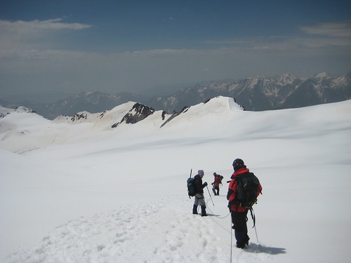
IMG_1235

As we continued through the crevasse field and the bowling alley of rocks it was even more important that I keep up. I recognized this and pushed as hard as I could and we did clear the field fairly smoothly. As we cleared the field and walked up onto the moraine again, we caught up to the other rope team we passed earlier. At this point we were able to unrope and proceed at our own pace. It took 30 minutes for Vidar and our two guides to get back to the meterological station. I took over an hour. Total time up and down: 11.5 hours.
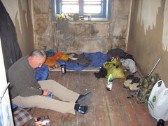
Lap of luxury in the Meteo Station

After arriving back at our "room", I pushed a bottle of Endurox into me. (Read: liquid calories) Solid foods hadn't appealed to me in over 12 hours and they certainly didn't now. I took a nap and when I woke up felt a little better. I managed to force down some Mac & Cheese, then read for a while before going back to bed for the night.


Wednesday morning, around 7 am we woke up to start heading home. It had rained for several hours the night before and the weather was still looking bad on the summit. Any teams planning on an attempt today would have to wait. I still couldn't hold down any solid foods so some more Endurox and down the hill we go at 8:20am.
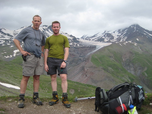
IMG_1247

It took us 3.5 hours to go from the campsite, across the glacier to the meterological station. It took us 1 hour to descend. After a short break at the campsite, we found that the rains from the night before had made our creek into a raging torrent and we could no longer find a path across. Our guide managed to get across, rigged a rope and we all got across. However everyone got wet up to their knees in doing so. Crossing the river took us an hour. But then it was an easy hour and a half down the mountain to the church. 12:00 on Wednesday we were at the church headed home.

That's the details on the trip. I'll try to add some more entries on the personalities side a bit later. Overall it was an awesome trip. Beautiful scenery and I really got a chance to appreciate how quickly the mountains are changing. The massive glaciers are dwarfed by the size of the mountain. However the glaciers carve huge trenches through the mountains and these trenches lead to more and more erosion. Even though these forces are acting on a geologic time scale it was very easy to feel that it was happening very fast and right now.

Absolutely worth it. Extremely challenging. But absolutely worth it.

  © Free Blogger Templates Blogger Theme by Ourblogtemplates.com 2008

Back to TOP